
Django SQL Injection Vulnerability CVE-2026-1207 Exploited in Real-World Attacks


 5 min. read
  Published on

A SQL injection vulnerability in Django is being targeted in real-world attacks against applications that use GeoDjango with the PostGIS backend.
The flaw, tracked as CVE-2026-1207, affects raster lookups on GIS fields when untrusted input is used as a band index. The Django security release described the issue as high severity and shipped fixes on February 3, 2026.

Access content across the globe at the highest speed rate.
🔥 Save 81% + 2 bonus months! 🔥
70% of our readers choose Private Internet Access
70% of our readers choose ExpressVPN
2
Browse the web from multiple devices with industry-standard security protocols.
🔥 Save 73%! 🔥

Faster dedicated servers for specific actions (currently at summer discounts)
🔥 Save 69%! 🔥
Administrators should treat the bug as urgent if their Django applications expose geospatial raster queries to user-controlled input. CrowdSec says it has seen a steady stream of exploitation attempts against the vulnerability, with activity starting in late February 2026, according to its CVE-2026-1207 report.
What is CVE-2026-1207?
CVE-2026-1207 is a SQL injection vulnerability in Django’s GIS functionality. The issue sits in raster lookups on RasterField, a feature implemented only for PostGIS-backed deployments.
The NVD entry says the flaw affects Django 6.0 before 6.0.2, Django 5.2 before 5.2.11, and Django 4.2 before 4.2.28. It also notes that earlier unsupported Django branches were not evaluated and may also be affected.
The vulnerable code path can allow remote attackers to inject SQL through the band index parameter. In practical terms, an exposed application could let an attacker interfere with database queries tied to geospatial raster data.
| Item | Details |
|---|---|
| CVE ID | CVE-2026-1207 |
| Component | GeoDjango RasterField lookups |
| Backend | PostGIS |
| Weakness type | SQL injection, CWE-89 |
| First patched versions | Django 6.0.2, 5.2.11, and 4.2.28 |
Why the vulnerability matters
Django’s standard ORM protections reduce SQL injection risk in normal application code, but this bug affects a narrower geospatial feature. That smaller scope does not make the risk minor for exposed systems.
Applications that use GeoDjango and PostGIS often support mapping, logistics, real estate, public-sector datasets, environmental systems, location analytics, and other data-heavy services. If those applications pass untrusted input into raster lookup band indexes, attackers may reach a sensitive database query path.
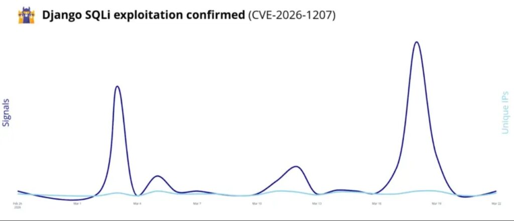
The CrowdSec report says the attacks do not look like a broad, noisy scanning wave. Instead, the observed activity points to focused reconnaissance for vulnerable Django and PostGIS configurations.
Affected Django versions
Django fixed the issue in the February security release. The first patched versions were 6.0.2, 5.2.11, and 4.2.28, according to the Django advisory.
Because Django has released newer security updates since then, teams should upgrade to the latest supported release in their branch where possible. The July 2026 Django security release shows that supported branches have continued to receive security fixes after the original CVE-2026-1207 patch.
- Django 6.0 users should run 6.0.2 or later, preferably the latest supported 6.0 release.
- Django 5.2 users should run 5.2.11 or later, preferably the latest supported 5.2 release.
- Django 4.2 users should run 4.2.28 or later if they still maintain that branch.
- Unsupported Django branches should be reviewed carefully because NVD says older series were not evaluated.
How attackers can exploit the flaw
The vulnerable path involves raster lookups that use a band index. When an application allows untrusted input to control that band value, malicious SQL fragments can reach the generated database query.
An attacker would typically look for endpoints that accept geospatial raster query parameters. From there, they may try crafted requests that trigger database errors, confirm injection behavior, or extract structured information from the backend.
The NVD record classifies the issue under SQL injection and identifies the affected version ranges. That makes the vulnerability easier for security teams to track across scanners, software bills of materials, and patch-management tools.
What administrators should do now
Organizations should first check whether they use Django’s GIS module with PostGIS and RasterField lookups. Systems that do not use this configuration face a much lower risk from this specific flaw.
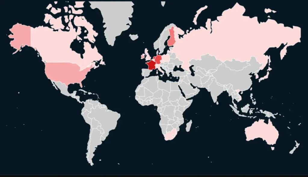
For exposed deployments, patching should take priority. Teams should also inspect request logs for suspicious raster-related parameters, SQL error responses, and repeated probing of geospatial endpoints.
Useful response steps include:
- Inventory Django applications that use GeoDjango, PostGIS, and RasterField.
- Upgrade affected Django versions to a patched and supported release.
- Validate all user-controlled band index input before it reaches ORM lookups.
- Review logs for unusual requests involving raster lookup parameters.
- Disable debug output in production to reduce database error leakage.
- Add WAF or application-layer rules for known exploit patterns after testing them against legitimate traffic.
Why patching alone may not be enough
Patching closes the framework-level flaw, but applications should still validate user input before it reaches database logic. Django’s own release notes remind developers to validate untrusted input before use.
Security teams should also confirm that production systems do not expose verbose database errors. Error output can help attackers refine SQL injection attempts and map application behavior.
The July Django security release also reinforces a broader point for administrators: keeping Django current matters because security fixes continue beyond one isolated CVE.
FAQ
Yes. CrowdSec reported real-world exploitation attempts against CVE-2026-1207, with activity observed after the vulnerability became public. The exploitation appears focused on Django applications that use GeoDjango with the PostGIS backend.
The vulnerability affects Django 6.0 before 6.0.2, Django 5.2 before 5.2.11, and Django 4.2 before 4.2.28. Older unsupported Django branches were not evaluated and may also be affected.
No. The flaw affects Django applications that use GIS raster lookups on RasterField with the PostGIS backend, especially when untrusted input controls the band index parameter.
Administrators should upgrade Django to a patched supported release, review whether their applications use GeoDjango with PostGIS RasterField lookups, validate band index input, and inspect logs for unusual raster query activity.


Read our disclosure page to find out how can you help VPNCentral sustain the editorial team Read more


Improve this guide




User forum
0 messages